- Home
-
Services

Services
Information about Council's regular services and programs.
-
Community

Community
Information about Council's community initiatives and support.
-
Business

Business
Information about doing business and investing in the shire.
-
Development

Development
Information about Building and Development in the Bega Valley Shire.
-
Council

Council
Information about how Council operates.
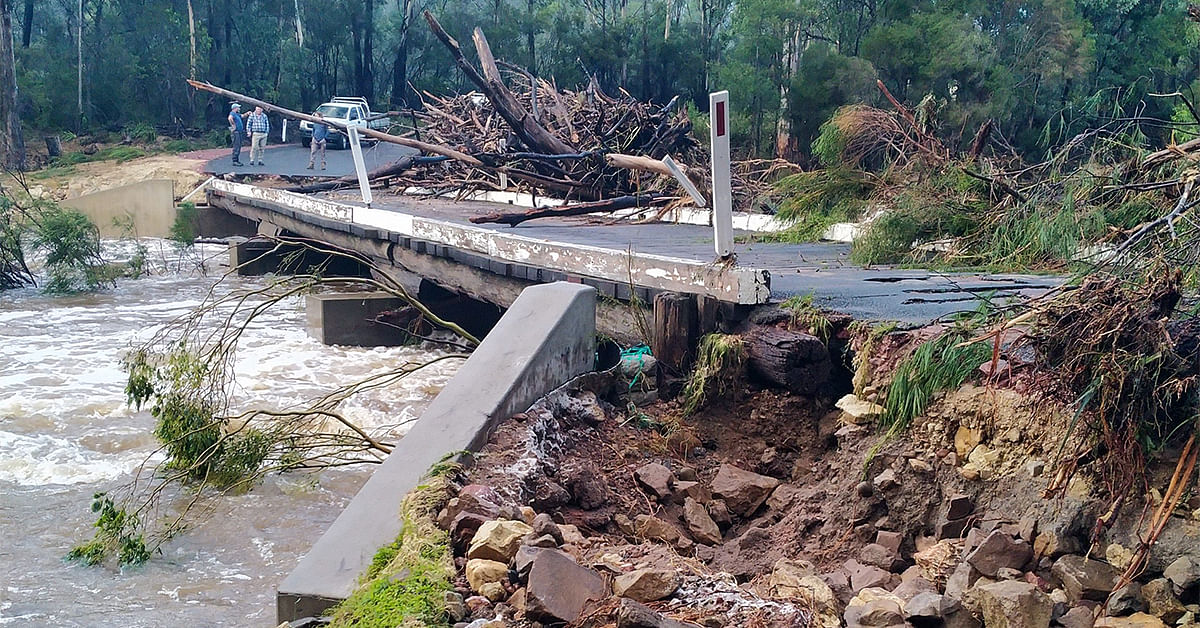
Pambula River, Pambula Lake and Yowaka River Flood Study
The publication of the flood study findings and results for the target catchments.
Background
The study was undertaken in response to increased development pressure, emergency response and asset infrastructure issues arising from recent Shire wide flood events in 2011, 2012 and 2016. The completed study allows updates to current flood mapping to improve floodplain risk management outcomes and emergency response planning.
Subsequently, during 2018 Bega Valley Shire Council commissioned a flood study for the Pambula River, Pambula Lake and Yowaka River catchments with financial and technical assistance from the NSW State Government Floodplain Management Grant Program. Utilising the grant funding, Council engaged consulting engineers Catchment Simulation Solutions to assist. The study was completed and formally endorsed by Council at its meeting of 21 July 2021.
Why undertake a flood study?
The flood study defines the current and future anticipated flood behaviour in the study area that included Pambula, South Pambula, Pambula Beach, Greigs Flat, Lochiel, Nethercote and Broadwater and their environs. The completed study provides Council and its community with information to better understand, plan and manage the risk of flooding across the study area
The study, was prepared to meet the objectives of the NSW State Government’s Flood Prone Land Policy. The study establishes the basis for subsequent floodplain management activities. The flood study forms an initial stage towards development of a comprehensive Floodplain Risk Management Plan, in accordance with the NSW Floodplain Development Manual, the management of flood liable land, April 2005.
Under the State Policy, NSW Local Governments are responsible for identifying and managing the risk to life and property from flooding. One of the most important steps in this process is increasing our community’s awareness of flooding so people are better able to understand and plan for flood risks they face.
What is the study about?
The flood risk was assessed using computer flood models that assisted in defining the likely depth and speed of water movement along each creek and river. The assessments included the following locations:
- Pambula River and floodplain from Mount Darragh Road to the Tasman Sea
- Yowaka River and floodplain from Back Creek Road to the Pambula River junction
The study has also assessed the flood risk of local rainfall within the Pambula, South Pambula and Pambula Beach village areas.
Although your property may be located within the catchment, this does not necessarily mean your property is impacted by flooding. However, property owners who are planning redevelopment of their property may need to take some additional steps as part of the consent process because flood-related development controls may apply. For example, the construction of new buildings may need to be set at or above suitable Flood Planning Levels to minimise flood risk.
The study outputs will allow Council, its community and other key emergency response stakeholders to better inform strategic land-use planning, asset and emergency response planning.
How were the study outputs derived?
Consultation with local residents within the catchments was completed using a community flood questionnaire during September 2019. Consultation with relevant State agency stakeholders also occurred during the initial consultation period. A community flood questionnaire and a number of print media releases occurred throughout the project for data collection and information. Further consultation was completed throughout the project via the Bega Valley Shire Floodplain Risk Management Focus Group, in which the community, State agencies and Council are represented.
The information derived from the initial community engagement phase was used to calibrate computer models to represent the behaviour of a number of historical floods. Once the models were calibrated against historical data and flood levels, differing intensities of flood event were then able to be derived.
Environmental concerns such as climate change, including sea level rise, were considered in the final flood study, in accordance with current NSW Government guidelines and requirements for flood study projects. Other environmental concerns are usually addressed in subsequent Floodplain Risk Management Study (FRMS) and Floodplain Risk Management Plan (FRMP) projects following a flood study
Final consultation of the preliminary findings was then carried out via formal public exhibition for 5 weeks during March – May 2021 and public comment and submissions were invited and evaluated for inclusion in the final study findings before the study was formally endorsed by Council 21st July 2021.
The study results
- Pambula River, Pambula Lake, Yowaka River Flood Study – Summary
- Pambula River, Pambula Lake, Yowaka River Flood Study - Main Report
- Pambula River, Pambula Lake, Yowaka River Flood Study - Final Report
- Pambula River, Pambula Lake, Yowaka River Flood Study - Appendix J - Roadway Inundation Information
- Pambula River, Pambula Lake, Yowaka River Flood Study - Appendix A - Community Consultation
- Pambula River, Pambula Lake, Yowaka River Flood Study - Appendix K - Sensitivity Analysis Difference Maps
- Pambula River, Pambula Lake, Yowaka River Flood Study - Calibration Maps
- Pambula River, Pambula Lake, Yowaka River Flood Study - Climate Change - Part 1
- Pambula River, Pambula Lake, Yowaka River Flood Study - Climate Change - Part 2
- Pambula River, Pambula Lake, Yowaka River Flood Study - Design Floodwater Depth and Level Maps
- Pambula River, Pambula Lake, Yowaka River Flood Study - Design Floodwater Speed Maps
- Pambula River, Pambula Lake, Yowaka River Flood Study - Flood Emergency Response Classifications
- Pambula River, Pambula Lake, Yowaka River Flood Study - Flood Hazard Maps
- Pambula River, Pambula Lake, Yowaka River Flood Study - Flood Planning Maps
- Pambula River, Pambula Lake, Yowaka River Flood Study - Hydraulic Category Maps - Part 1
- Pambula River, Pambula Lake, Yowaka River Flood Study - Hydraulic Category Maps - Part 2
- Pambula River, Pambula Lake, Yowaka River Flood Study - Tidal Inundation Maps
Study timeline
-
September 2019
Stage 1: Data Collection - Data reviews, communtiy consultation and survey.
-
January 2020
Stage 2: Modelling and Calibration - model establishment and calibration to historic data.
-
July 2020
Stage 3: Draft Flood Study - scenario modelling and public exhibition (March - May 2021).
-
July 2021
Stage 4: Final report - endorsement.
© Bega Valley Shire Council 2025
Our council websites
Contact Us
- 02 6499 2222
- council@begavalley.nsw.gov.au
-
Zingel Place
PO Box 492
Bega NSW 2550 -
Monday to Friday 9.00AM to 4.30PM
Administration building Zingel Place Bega
Australia -
ABN: 26 987 935 332