- Home
-
Services

Services
Information about Council's regular services and programs.
-
Community

Community
Information about Council's community initiatives and support.
-
Business

Business
Information about doing business and investing in the shire.
-
Development

Development
Information about Building and Development in the Bega Valley Shire.
-
Council

Council
Information about how Council operates.
Wolumla Flood Study
This study will improve Council’s understanding of flood behaviour and it’s impacts on the community, and better inform management of flood risk in the study area.
Project background
Bega Valley Shire Council has engaged Rhelm Consultants to assist with the preparation of the Wolumla Flood Study and subsequent Floodplain Risk Management Study and Plan. This study will improve Council’s understanding of flood behaviour and impacts on the community, and better inform management of flood risk, future strategic land-use planning, infrastructure planning and emergency response planning in the area.
Why we need this study
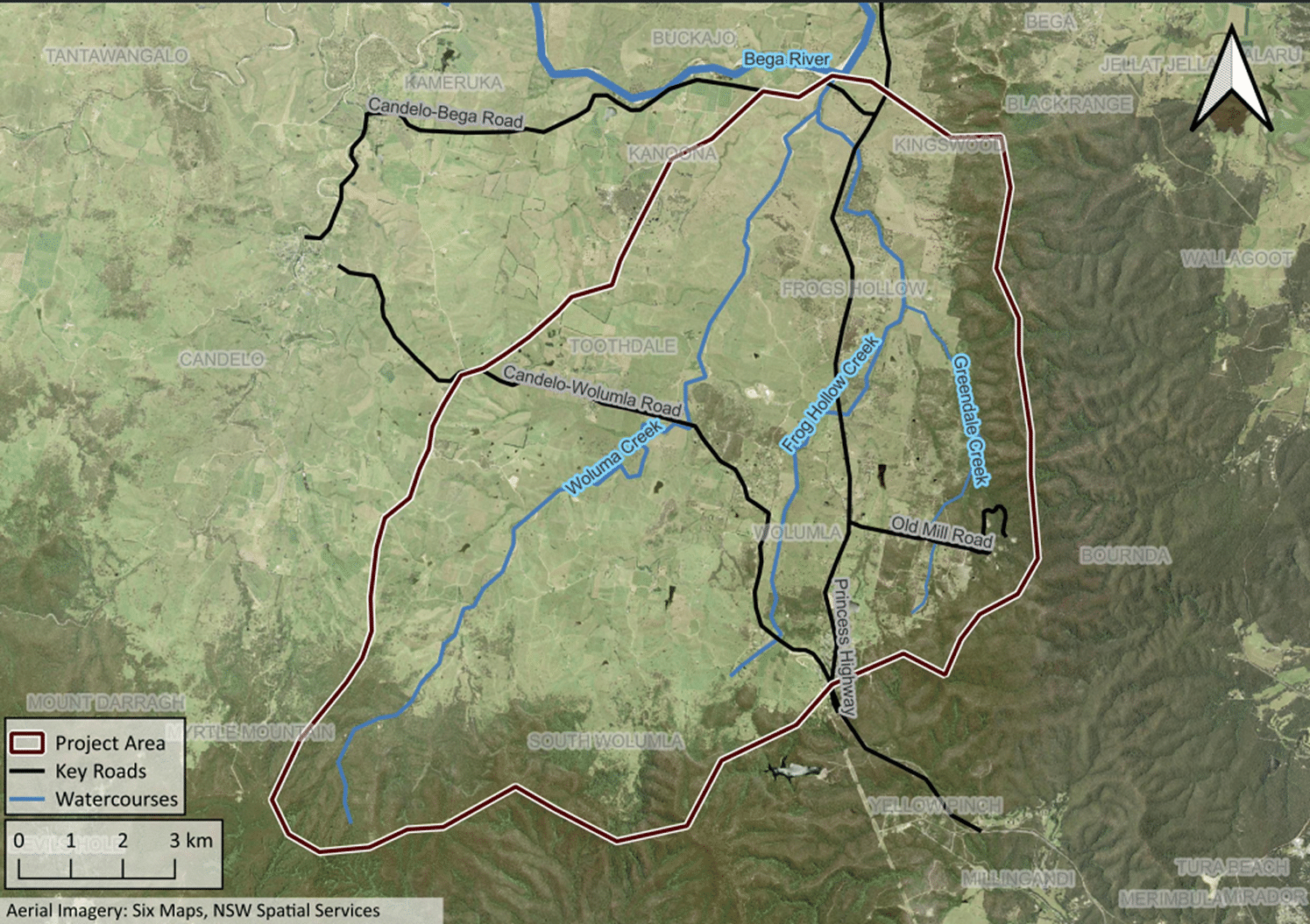
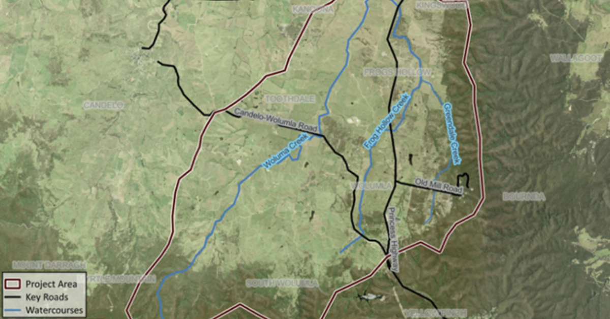
The study area encompasses the Wolumla Creek catchment focusing on the localities of Wolumla, South Wolumla and Frog's Hollow and four areas that were previously part of a 2018 Wolumla Planning Proposal. The deferred matters identified as part of the Planning Proposal then have now since all been resolved.
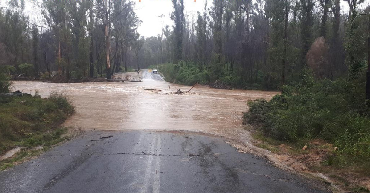
Wolumla Creek is a tributary of the Bega River, and the floodplain and portions of the Wolumla Creek catchment can be subject to both mainstream and overland flow flooding.
There is currently no Flood Study or associated mapping for this area to assist Council and emergency services to plan for and manage the catchment flood risk.
With two regional roads transiting the Wolumla Creek catchment, detailed flood information is needed for emergency response and infrastructure planning. Additionally, development pressures in and around the township of Wolumla highlight the need to understand flood risks associated with overland flow, road access and future strategic land-use planning.
The Flood Study represents the first assessment phase of the floodplain risk management process. It defines the existing flood behaviour and flood risks present in the study area. This information will feed into a subsequent Floodplain Risk Management Study and Plan which will assess various methods of managing this risk and ultimately prepare an implementation plan of management options for Council.
This project will be undertaken in accordance with the NSW Flood Prone Land Policy, the NSW Flood Risk Management Manual (2023) and in close collaboration with the NSW State Emergency Services (SES), the NSW Department of Climate Change, Energy, the Environment and Water (DCCEEW), and other agencies and stakeholders as required.
Funding
Council received partial funding from the NSW Department of Planning and Environment under the NSW Government Floodplain Management Program to assist with the completion of the study.
- Total - $180,000
- NSW Government - $120,000
- Council contribution $60,000
Connection to Council's Community Strategic Plan
This project aligns with Bega Valley Shire Council Community Strategic Plan through:
- Our Environment
Strategy C.5: Lead climate change mitigation and adaptation through implementation of our Climate Resilience Strategy focusing on natural systems, preparing for natural hazards, liveable and connected places, safe, healthy and inclusive community, diverse and thriving economy, energy security and food security. - Our infrastructure
Strategy D.1: Plan for community infrastructure and services that will meet current and future needs.
Who to talk to
Gemma Gill
Civil Assets Superintendent
Bega Valley Shire Council
Email: ggill@begavalley.nsw.gov.au
Phone: (02) 6499 2222
Derek Van Bracht
Environmental Management Coordinator
Bega Valley Shire Council
Email: dvanbracht@begavalley.nsw.gov.au
Phone: (02) 6499 2222
Timeline of works
-
10 Oct 2023
The study commenced with a project initiation between Council and DCCEEW (then DPIE) staff with the consultants; Rhelm.
-
17 May to 2 June 2024
- First round community consultation
- A community survey was made available online 17 May 2024 – 2 June 2024 and then extended for a further two weeks on Council’s website.
- Door knocking occurred on 29 May 2024 within the village
- A drop-in information session was held at the Wolumla Public School also on 29 May 2024
- First round community consultation
-
18 April 2025
- Public exhibition period commences
- The draft Flood Study on exhibition from 18 April to 18 May 2025, with a drop-in session to be held at Wolumla Public School.
- Public exhibition period commences
-
Mid to late 2026
Flood Study and Floodplain Risk Management Study and Plan endorsed by Council.
Frequently Asked Questions
A 1 in 100 year flood is a flood event that has the probability of occurring on average once every 100 years, i.e. there is a 1% chance of a flood of this size occurring at a particular location in any given year. This does not mean that if a location floods one year that it will not flood for the next 99 years. Nor, if it has not flooded for 99 years that it will necessarily flood the next year. Some parts of Australia have experienced more than one ‘1 in 100 year’ floods within a decade of each other. Within the draft Flood Study the ‘1 in 100 year’ flood is referred to as the 1% AEP (Annual Exceedance Probability) flood event.
The Flood Planning Level (FPL) is a height used to set floor levels for property development in flood prone areas. It is generally defined as the 1% AEP flood level plus an appropriate freeboard (see explanation of ‘freeboard’ below). This level may be higher for vulnerable land uses (e.g. hospitals or schools).
The flood planning area is the area within which developments may be conditioned with flood related development controls. The flood planning area is calculated as the area below the Flood Planning Level.
A freeboard is a height above the 1% AEP flood level that is included in the Flood Planning Level to account for factors such as wind, waves, unforeseen blockages and other localised hydraulic effects. Freeboard is set for a given catchment area based on the local flood behaviour and risk.
The Flood Study provides a preliminary assessment of the impacts of sea level rise and changes in rainfall. The impacts of climate change are not included in the design flood maps (e.g. 1% AEP flood depths).
Council’s flood modelling determines the extent of flooding throughout the catchment and the identification of properties partially or fully impacted by flooding.
Council already has a number of published flood studies and floodplain risk management plans for select areas on its website available here.
In some instances, residents may need to engage a registered surveyor or flood engineer to determine the flood level on their property where no detailed studies exist.
If the situation is life threatening you should call 000.
For other assistance during an emergency such as flood, storm or tsunami, please contact the NSW State Emergency Service (SES) on 132 500 or visit their website at www.ses.nsw.gov.au.
It is best to be prepared for any flood. The State Emergency Service provides advice on how to manage your flood risk at floodsafe.com.au.
NSW Councils have responsibility for identifying and managing flooding, and informing the community. Councils follow the NSW Flood Prone Land Policy, which outlines how Councils should manage flooding, to reduce the risk to people and properties as described within the NSW Floodplain Risk Management Manual (2023).
Councils prepare Flood Studies and Plans according to the NSW Government's Flood Risk Management Manual (2023) and implement associated recommendations with technical and financial assistance from the NSW Government and key stakeholders through the Flood Prone Land Policy.
If the situation is life threatening you should call 000.
For other assistance during an emergency such as flood, storm or tsunami, please contact the NSW State Emergency Service (SES) on 132 500 or visit their website at www.ses.nsw.gov.au.
It is best to be prepared for any flood. The State Emergency Service provides advice on how to manage your flood risk at floodsafe.com.au.
There are three main ways of managing flood risk:
- emergency management
- property modification
- flood modification
Emergency management measures seek to help people at risk during a flood. This includes sharing information with the State Emergency Service, flood warning systems and identifying evacuation routes and locations of emergency refuge centres.
Property modification measures consider the way in which land is used, the buildings that are on it and the extent of flooding on a property. These measures are typically addressed in Local Environmental Plans and Development Control Plans.
Flood modification measures change the behaviour of flood waters with structural methods. This may include levees, creek management, estuary entrance management and improved stormwater infrastructure.
The information from the adopted study outcomes will be used to inform future floodplain risk management activities to manage the identified flood risk. Some of the study outputs and/or future activities will better inform land-use planning outcomes, emergency response and strategic asset planning. Where a house may be in an identified flood zone, certain land-use planning or development controls may apply. The relevant land-use planning or development controls are typically noted on a section 10.7(2) certificate that list the relevant controls for a parcel of land. The study outcomes will be used to inform and review existing section 10.7(2) certificates, emergency response and strategic asset plans for the relevant catchment area.
There is a chance that floods of any size will occur in the future. As the size of a flood increases, the chances of it occurring becomes smaller. Because some rare types of floods have not occurred for over a century, the height of future floods is predicted using computer-based models. These models simulate different flood levels, speeds and direction for different sized floods.
Given the importance of accurately predicting flood levels and information, Council engages experts to establish and operate these computer-based models.
From time to time, these models are reviewed, and predicted flood levels may change slightly. The reason why the models are revised can include:
- New floods occurring, providing additional data to fine-tune the model
- Flood mitigation works undertaken may change flood levels
- More advanced computer-based models becoming available
- Development within the floodplain (which may be outside our control)
- Changes in technical guidelines and requirements
- Changes in State or Local policies.
For the Wolumla region, no models have been developed. The development of computer-based models to predict flood behaviour is a key outcome of this study.
A Flood Study provides technical information on the likelihood and characteristics of flooding within a catchment. It provides detailed information about the nature of flood risk including the distribution, extent, depths, levels, and speed and direction of floodwaters for a range of storm events, including a 1 in 100-year flood.
A floodplain risk management study and plan examines flood behaviour and identifies and prioritises options to help protect people and property through better planning, emergency management and infrastructure works.
Wolumla flood study area
News and Updates
© Bega Valley Shire Council 2025
Our council websites
Contact Us
- 02 6499 2222
- council@begavalley.nsw.gov.au
-
Zingel Place
PO Box 492
Bega NSW 2550 -
Monday to Friday 9.00AM to 4.30PM
Administration building Zingel Place Bega
Australia -
ABN: 26 987 935 332