- Home
-
Services

Services
Information about Council's regular services and programs.
-
Community

Community
Information about Council's community initiatives and support.
-
Business

Business
Information about doing business and investing in the shire.
-
Development

Development
Information about Building and Development in the Bega Valley Shire.
-
Council

Council
Information about how Council operates.
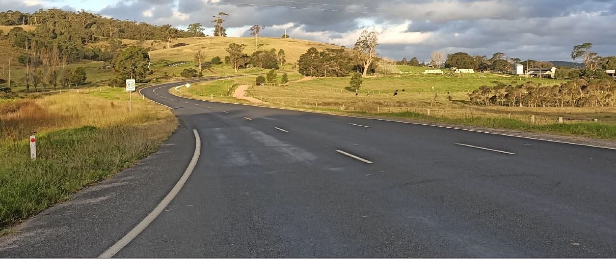
Bega to Kalaru Shared Path
Council is undertaking a feasibility study to determine the viability of creating a shared path from Kalaru to Bega.
Project Summary/background
Council was successful in securing an Active Transport grant of $3.12m from the NSW Government for the construction of the first stage of a shared path from Tathra to Kalaru. This included funding to undertake a feasibility study for a proposed second stage of the shared path, from Kalaru to Bega closely following the existing road corridor and approximately 10km in length.
The feasibility study will consider the full range of users from primary and secondary school children through to recreational and commuter users, and include accessibility considerations.
It will investigate both on and off-road options, and potentially a combination of both, considering environmental constraints, land tenure (including the potential need for Council to acquire privately owned land), and cost (including a cost benefit analysis).
The route alignment options will address the following key considerations.
- Safety – Minimal risk of traffic related injury, low perceived danger, space to ride, minimum conflict with vehicles
- Coherence – Infrastructure should form a coherent entity, link major trip origins and destinations, have connectivity, be continuous, signed, consistent in quality, easy to follow and have route options
- Directness – Route should be direct, based on desire lines, have low delay through routes for commuting, avoid detours and have efficient operating speeds
- Attractiveness – Lighting, personal safety, aesthetics integration with surrounding area, access to different activities
- Comfort – Smooth skid resistant riding surface, gentle gradients, avoid complicated manoeuvres, reduced need to stop, minimum obstruction from vehicles
Purpose
The feasibility study is part of the future planning for a shared path from Kalaru to Bega, building upon the recently constructed shared path from Kalaru to Tathra and providing a complete shared path for active transport users from Tathra to Bega. It will provide an estimate of costs and recommendations for route alignment, materials, signage, safety and amenity.
Funding
The funding for the feasibility study was made possible through the NSW’s Government Active Transport Funding.
Importantly, Council only has funding for the feasibility study at this stage, with the outcome of the study to form the basis of future funding applications.
Connection to Council's Community Strategic Plan
This project is connect to Council's Community Strategic Plan through Outcome 5; Goal 10.
- Outcome 5: Connected Communities
- Goal 10: We have a network of good quality roads, foot paths and cycleways connecting communities throughout the Shire and beyond.
The project also aligns with the Vision and Goals and Short-Term Priority proposals of the Bega Valley Bike Plan.
Who can I speak to:
- Daniel Djikic
Manager Project Services
Bega Valley Shire Council
Phone: (02) 6499 2222 - Nikki Edwards
Buildings and Shared Network Specialist
Bega Valley Shire Council
Phone: (02) 6499 2222
Timeline of works
-
March/April 2021
Stage 1: Inception and site investigation.
-
May 2021
Stage 2: Background review.
-
May/June 2021
Stage 3: Options development and assessment.
-
July/September 2021
Stage 4: Public consultation.
-
September/December 2021
Stage 5: Review of Environmental Factors.
Stage 6: Engineering report and costings.
-
January - April 2022
Stage 7: Feasibility reporting.
-
June 2022
Stage 8: Report to Council and recommendation.
Proposed options of the path route
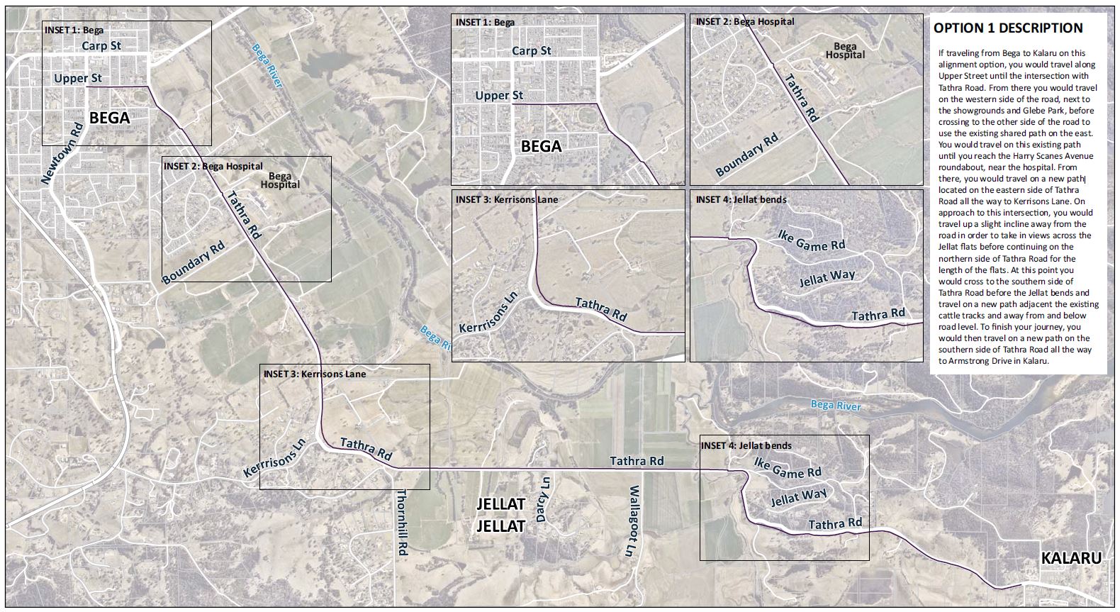
If traveling from Bega to Kalaru on this alignment option, you would travel along Upper Street until the intersection with Tathra Road. From there you would travel on the western side of the road, next to the showgrounds and Glebe Park, before crossing to the other side of the road to use the existing shared path on the east. You would travel on this existing path until you reach the Harry Scanes Avenue roundabout, near the hospital. From there, you would travel on a new path located on the eastern side of Tathra Road all the way to Kerrisons Lane. On approach to this intersection, you would travel up a slight incline away from the road in order to take in views across the Jellat flats before continuing on the northern side of Tathra Road for the length of the flats. At this point you would cross to the southern side of Tathra Road before the Jellat bends and travel on a new path adjacent the existing cattle tracks and away from and below road level. To finish your journey, you would then travel on a new path on the southern side of Tathra Road all the way to Armstrong Drive in Kalaru.
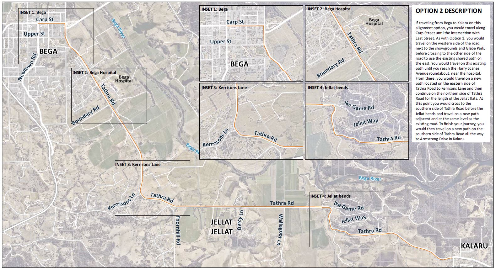
If traveling from Bega to Kalaru on this alignment option, you would travel along Carp Street until the intersection with East Street. As with Option 1, you would travel on the western side of the road, next to the showgrounds and Glebe Park, before crossing to the other side of the road to use the existing shared path on the east. You would travel on this existing path until you reach the Harry Scanes Avenue roundabout, near the hospital. From there, you would travel on a new path located on the eastern side of Tathra Road to Kerrisons Lane and then continue on the northern side of Tathra Road for the length of the Jellat flats. At this point you would cross to the southern side of Tathra Road before the Jellat bends and travel on a new path adjacent and at the same level as the existing road. To finish your journey, you would then travel on a new path on the southern side of Tathra Road all the way to Armstrong Drive in Kalaru.
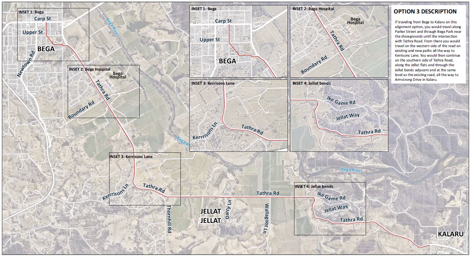
If traveling from Bega to Kalaru on this alignment option, you would travel along Parker Street and through Bega Park near the showgrounds until the intersection with Tathra Road. From there you would travel on the western side of the road on existing and new paths all the way to Kerrisons Lane. You would then continue on the southern side of Tathra Road, along the Jellat flats and through the Jellat bends adjacent and at the same level as the existing road, all the way to Armstrong Drive in Kalaru.
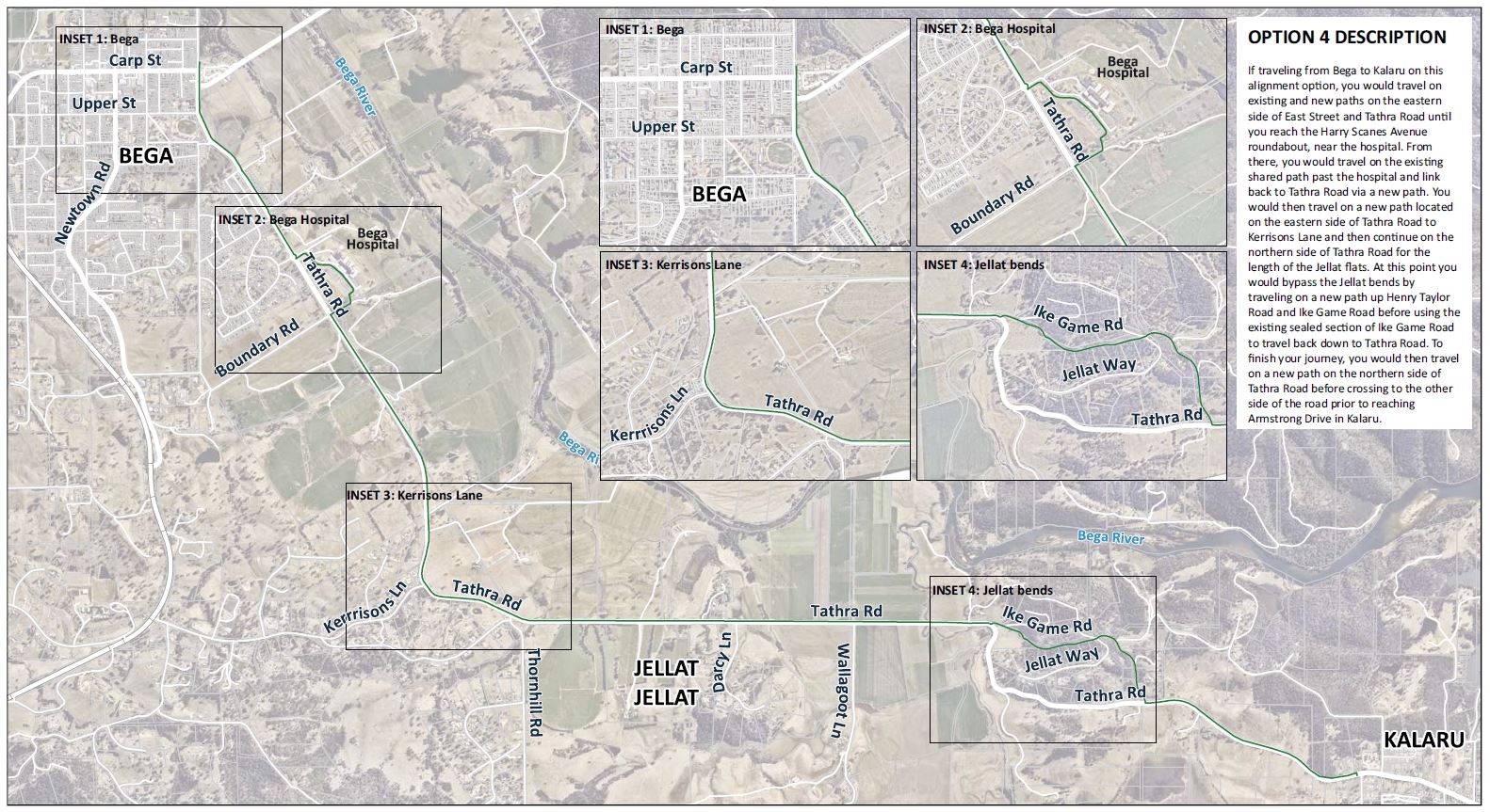
If traveling from Bega to Kalaru on this alignment option, you would travel on existing and new paths on the eastern side of East Street and Tathra Road until you reach the Harry Scanes Avenue roundabout, near the hospital. From there, you would travel on the existing shared path past the hospital and link back to Tathra Road via a new path. You would then travel on a new path located on the eastern side of Tathra Road to Kerrisons Lane and then continue on the northern side of Tathra Road for the length of the Jellat flats. At this point you would bypass the Jellat bends by traveling on a new path up Henry Taylor Road and Ike Game Road before using the existing sealed section of Ike Game Road to travel back down to Tathra Road. To finish your journey, you would then travel on a new path on the northern side of Tathra Road before crossing to the other side of the road prior to reaching Armstrong Drive in Kalaru.
News and Updates
-

Have your say on options for the Kalaru to Bega shared path
Wed, 28 Jul 2021
MEDIA RELEASE 2021 - Council is seeking feedback from the community to inform the feasibility study for a future shared path from Kalaru to Bega.
-
Community support for Kalaru to Bega shared path
Fri, 29 Oct 2021
MEDIA RELEASE 2021 - Community feedback on four draft route alignments for a future Kalaru to Bega shared path has been completed, with over 245 surveys completed.
© Bega Valley Shire Council 2025
Our council websites
Contact Us
- 02 6499 2222
- council@begavalley.nsw.gov.au
-
Zingel Place
PO Box 492
Bega NSW 2550 -
Monday to Friday 9.00AM to 4.30PM
Administration building Zingel Place Bega
Australia -
ABN: 26 987 935 332