- Home
-
Services

Services
Information about Council's regular services and programs.
-
Community

Community
Information about Council's community initiatives and support.
-
Business

Business
Information about doing business and investing in the shire.
-
Development

Development
Information about Building and Development in the Bega Valley Shire.
-
Council

Council
Information about how Council operates.
About the Bega Valley Shire
The Bega Valley Shire and its surrounds... the unique coastline abounds in deserted beaches, tranquil rainforests, serene rivers and lakes, and picturesque mountain backdrops.
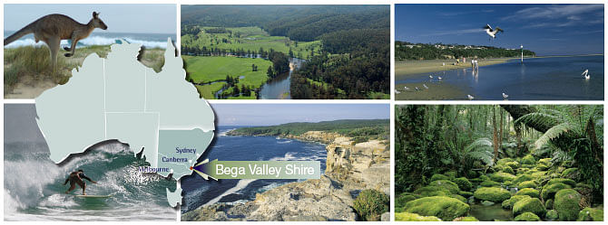
 The Bega Valley Shire is located at the south-eastern corner of New South Wales, half way between Australia’s two largest cities, Sydney and Melbourne and three hours’ drive from the nation’s capital, Canberra. At over 6,200 km2, the shire is the largest local government area in coastal NSW and has the longest coastline, stretching 225-kilometres forming the beautiful Sapphire Coast, the heart of Australia’s Coastal Wilderness. Almost 80% of the shire is National Park, State Forest or public reserve and large areas are used for agriculture. The shire’s combination of natural beauty, temperate climate and its range of towns, villages and recreational opportunities and commercial enterprises have attracted visitors and new residents for many years.
The Yuin people are the traditional custodians of the shire. Ancient stories, ceremonies, special places and sacred objects are embedded in the landscapes, trees, hills and waterways of the shire, and form the basis of traditional lore, custom, spiritual connection and custodial obligations.
The small population of around 35,000 is dispersed, with a third of us living in rural areas and the remaining two thirds spread amongst 12 villages, 4 major towns and adjacent urban settlements. Our main industries are agribusiness including fishing and aquaculture, health and social services, and tourism. Transport is predominantly by private car with limited bus services. Merimbula Airport provides air transport connectivity to Melbourne and Sydney and the Port of Eden is an important working port able to berth large cruise ships.
We are a regional centre for schools and higher education institutions. There are currently 18 primary and 4 high schools which include a mixture of private and public facilities. The University of Wollongong operates a campus in Bega. In addition, vocational courses and trade skills are offered by the Bega TAFE Illawarra campus.
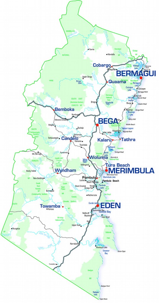
Towns within the Bega Valley Shire
...the rural centre of the Sapphire Coast, set at the gateway to the rolling pastures of the lush Bega Valley.
 Bega is set in a valley at the junction of the Bega and Brogo Rivers and surrounded by rich dairy country, Bega is a handsome, historic town with a proud tradition of cheese making.
It was founded in 1834 as the service centre for sheep farmers, who later turned to dairy and beef cattle, and it continues as a service town for the Shire with major shopping facilities, banks, educational and medical facilities, government departments, courthouse, regional gallery and stock saleyards to name a few.
 Headquarters for the Bega Valley Shire Council, electricity and gas providers, the Rural Fire Service and State Emergency Services are also located in Bega.
Bega is also home to the Bega Cheese Co-Operative Society, which trades as Bega Cheese and is the Shire’s biggest employer.
Visit our Sapphire Coast Tourism site and discover your ultimate year-round escape.
...Another timeless day dawns at Pambula, a name derived from the Yuin Aboriginal word meaning "Two Waters".
 Pambula is a pretty rural township and many of its buildings have historical significance. One of the best examples of these beautiful restored buildings is The Grange, located just south of Pambula, which was formerly the mansion of a local sea captain.
There is a range of shops including galleries and craft outlets, restaurants, cafes and two licensed hotels.
The town has a thriving industrial area and a strong Chamber of Commerce that promotes all that is unique about Pambula.
 The locals take pride in their town and spend many hours tending local gardens and flower beds.
The name Pambula was derived from a Yuin Aboriginal word, meaning ‘two waters’.
Nearby is Pambula Beach, a good surfing beach with a modern caravan park.
The beautiful Pambula Lake and River offer a range of aquatic experiences and are bordered by the Ben Boyd National Park.
Visit our Sapphire Coast Tourism site and discover your ultimate year-round escape.
...Merimbula's magic begins with a first glimpse of the beaches, brilliant beneath the bright sunshine.
 Merimbula is a vibrant, colourful coastal town that has made best advantage of these physical attributes to provide sought after residential and holiday opportunities.
It is also the ‘social hub’ of the Bega Valley Shire with an excellent range of restaurants and entertainment facilities.
While much of Merimbula is focussed on the present, there is a rich history to be explored. The town began its existence as a private village belonging to the Twofold Bay Pastoral Association which opened it as a port in 1855 and provided an important gateway to the district.
Situated around the beautiful waterways of two clean tidal lakes, Top and Back Lakes, Merimbula is the perfect site for the holiday town it is today.
 There are many beaches to be enjoyed around Merimbula. Gentle beaches suitable for small children are found around the lake foreshores while great surfing beaches outside the lake areas offer a variety of waves for board and body surfers. In fact, just about any water sport you could desire is available in/throughout Merimbula.
The shire’s airport, which is a Council asset leased to an operator, is located on the outskirts of Merimbula.
Visit our Sapphire Coast Tourism site and discover your ultimate year-round escape.
...The region is known as the ‘humpback highway’ and every year, between September and November, our waters play host to thousands of humpbacks heading home to Antarctica.
 Eden, situated on the deep harbour of Twofold Bay at the southern tip of the Shire, is rich in fishing and whaling history and remains a fishing town while whaling has become whale watching - one of the key tourist attractions in the town.
Although the actual whaling industry was abandoned in 1930, you can learn about it at Eden’s fascinating Killer Whale Museum. The museum sounds a siren when whales are in close proximity to vantage points around Twofold Bay on their migrations to and from the Antarctic.
The fishing industry is still one of the mainstays of Eden’s economy and a large fleet operates out of Eden from Snug Cove.
Visitors too can enjoy the thrill of a good catch as there are many great fishing spots in local lakes, rivers and from beaches and out at sea.
 The Sapphire Coast Marine Discovery Centre, located at Snug Cove, promotes understanding of oceans and coasts by offering learning and knowledge experiences and facilitating research into the temperate marine environment.
Eden supports a strong timber industry and is home to an export chipmill on the southern side of Twofold Bay. A separate naval wharf is located nearby.
Visit our Sapphire Coast Tourism site and discover your ultimate year-round escape.
...Bermagui hugs the edges of its harbour, and nestles under the shadow of Gulaga (Mt Dromedary), once an active volcano 60 million years ago.
 Bermagui, a coastal town and fishing harbour at the northern end of the Shire, is one of the prettiest.
Bermagui was made internationally famous by the American author Zane Grey who pioneered the sport of gamefishing here in the 1930s and thousands of people travel to Bermagui each year to enjoy fishing - the most popular sport in Australia.
The boat harbour has a safe all-weather entrance and a large launching ramp. There are facilities around Bermagui for fishers of all types including boat ramps, trailer parking and a gantry for weighing in the ‘one that didn’t get away’.
 The nearby Wallaga Lake Cultural Centre has a display of Aboriginal cultural history and contemporary activities.
The local commercial fishermen’s co-operative is currently redeveloping the area around the wharf and 30 hectares of land adjacent to the Bermagui Country Club has been rezoned to allow for residential, tourist and seniors housing development and the retention of significant environmental lands.
Visit our Sapphire Coast Tourism site and discover your ultimate year-round escape.
...Set like a gem into shades of green and blue, Tathra surrounds itself in the natural beauty of both Mimosa Rocks National Park to the north, and Bournda National Park to the south, home to many seabirds such as the endangered Little Tern and an abundance of wildlife.
 Tathra is a small coastal town situated between Merimbula and Bermagui and less than 20 minutes drive east of Bega.
This is a beautiful play area for people of all ages and the scenery and picnic areas will relax and inspire at the same time. It abounds in good fishing and swimming spots, boat ramps, bush walks and barbecue facilities at the inlet.
To the north of Mogareeka Inlet is the Mimosa Rocks National Park, a wonderful coastal park where hikers can enjoy the many walking trails.
At the other end of Tathra Beach is Tathra Headland on which is situated the famous historical Tathra Wharf which has been restored to its former glory and many people find it the perfect spot to set themselves up for a day’s relaxed fishing.
 The waters around the wharf are home to a variety of marine life and diving is very popular here.
At Kianinny Bay there is an excellent boat ramp suitable for launching even large vessels.
Nearby, a large saltwater lake, Wallagoot, is popular with water skiers, windsurfers, sailors and those keen on fishing and prawning.
Visit our Sapphire Coast Tourism site and discover your ultimate year-round escape.
© Bega Valley Shire Council 2025
Our council websites
Contact Us
- 02 6499 2222
- council@begavalley.nsw.gov.au
-
Zingel Place
PO Box 492
Bega NSW 2550 -
Monday to Friday 9.00AM to 4.30PM
Administration building Zingel Place Bega
Australia -
ABN: 26 987 935 332